
The wetlands have long been shaped by both natural forces and human activity. Human settlement in Qingshui dates back to the mid-Neolithic Niumatou culture, 3,500 to 4,500 years ago. During the Qing Dynasty, the area was first inhabited by the Atayal people, who were later displaced by the Papora. After suppressing Indigenous uprisings, the Qing colonial government established full control of Qingshui in 1699, stationing soldiers and officials to defend the region.
The Changhua County Chronicle in 1832 records the original name for Gaomei as Gaomi (篙密). Before the Western Coastal Highway was built, residents navigated Sikuacu Creek by boat to reach the wetlands for fishing. The water was so deep that the bamboo poles used to propel boats were nearly submerged, giving rise to the name “Gaomi.” In Taiwanese, gao (篙) sounds like gan (竿), meaning “pole,” while mi (密) conveys a sense of being submerged or engulfed. During the Japanese colonial period (1899–1945), the name was changed to Gaomei (高美), which translates literally as “high beauty.”

Under Japanese rule, Gaomei was developed with schools and a seaside bathing area. In 1932, it was formally opened as Gaomei Beach and quickly became a major tourist attraction, with Showa buses shuttling passengers along its roads. Tourism peaked in 1967, when the Republic of China government built the Gaomei Lighthouse, which became a major landmark. Yet the peak was short-lived: construction of a sand barrier at the north end of Taichung Port caused silt to accumulate along the beach, and visitor numbers declined. The area was officially closed in 1976.
What followed was two decades of relative silence, as Gaomei was neglected by a rapidly modernizing Taiwan. By the 1990s, however, interest began to reignite, driven by the area’s vast ecological resources, stunning scenery, and abundant wildlife, coinciding with growing global awareness of the importance of wetlands. In 2007, Gaomei was designated a national wetland, cementing its status as a significant site for conservation, research, and environmental education.
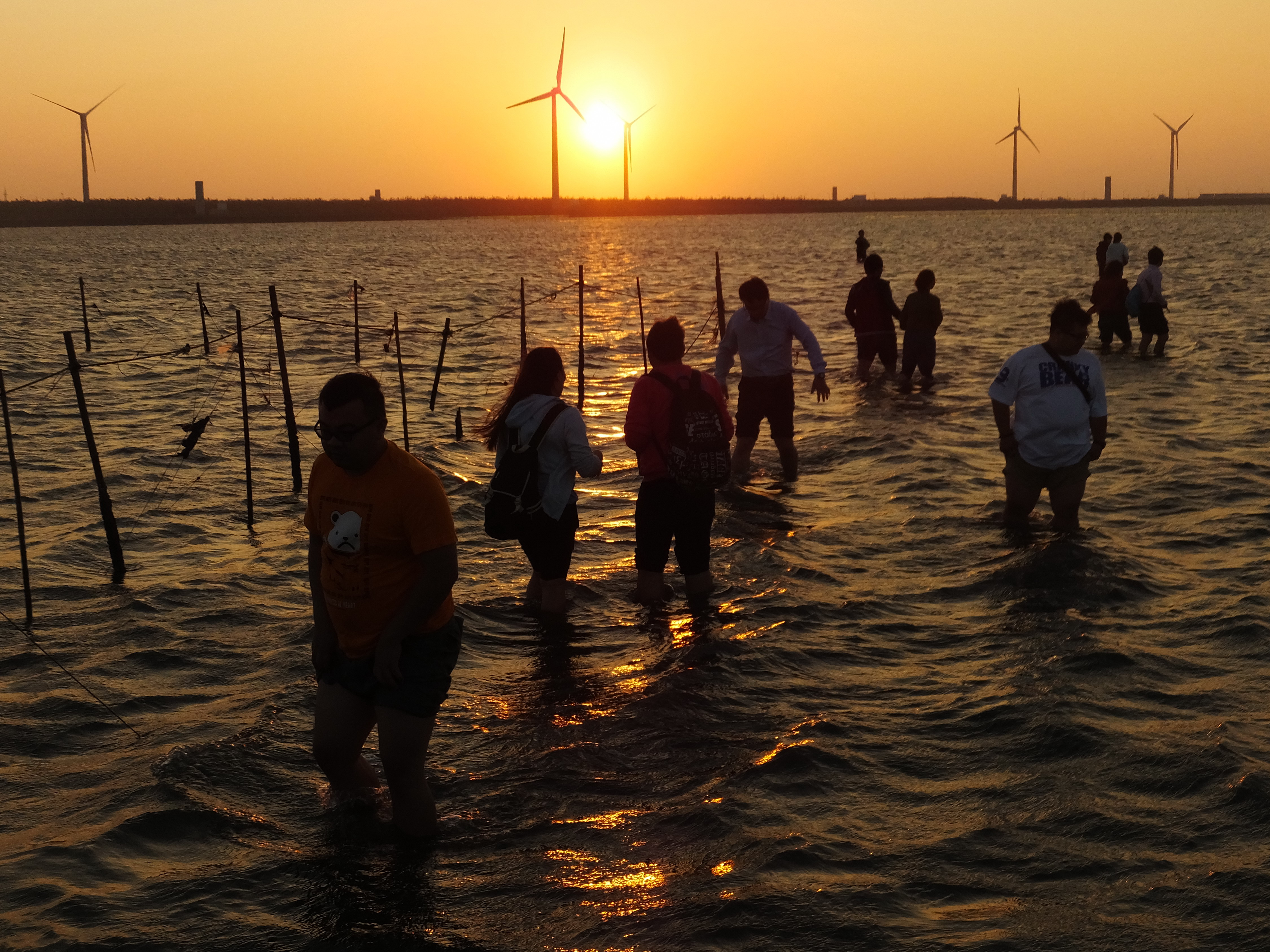
Tourism surged, with crowds flocking to experience Gaomei’s natural beauty and wildlife. Visitors often trampled fragile vegetation, caught crabs, and let children play on the mudflats. At the same time, locals converted adjacent lands into shops, restaurants, and parking areas to meet demand. This rapid growth has caused soil compaction, vegetation loss, and disruption of animal habitats, placing the wetlands’ future at risk.
For more than two decades, Hui-Chen Lin, a professor of wetland ecology in Tunghai University’s Department of Life Sciences, has led a team studying and monitoring the Gaomei Wetlands. White Fungus editor Ron Hanson interviewed Lin about the wetlands and her team’s work.
Ron Hanson
Today, the Gaomei Wetlands are regarded as one of Taiwan’s most spectacular scenic sites and biodiversity hotspots—valued by tourists, scientists, and conservationists alike—but our recognition of the importance of wetlands is relatively new. Until recent decades, such areas were often regarded as wastelands, with vast expanses destroyed around the world. Setting aside, for a moment, the economic benefits of the Gaomei Wetlands through tourism, what is their ecological significance for Taiwan? What role do they play in the island’s ecosystem?
Hui-Chen Lin
A wetland is a transitional area between water and dry land that is submerged either year-round or intermittently. Because its soil remains saturated for long periods, wetlands nurture a great diversity of species markedly different from those found in terrestrial environments. These ecosystems are the most productive on Earth per unit area, comparable to tropical rainforests.
They also provide resting sites for migratory birds, which use them as stopover points during long-distance migrations. In addition, wetlands play a crucial role in water purification. Studies have shown that a single hectare of wetland can purify as much water as a sewage treatment plant would for four million New Taiwan Dollars.
Wetlands perform a range of ecological functions, including water purification, flood control, coastal stabilization, carbon sequestration, and climate regulation. They harbor abundant natural resources and are biodiversity hotspots, providing habitats for migratory birds and other wildlife for resting and breeding. They also serve as important sites for environmental education and economic activities, including fishing.

RH
In 2007, the Gaomei Wetlands were officially designated as a protected area. Can you tell me about the movement that led to this recognition? Who were the principal actors, and what was their original vision for managing the wetlands?
HCL
In October 1996, the Haidu Power Company announced plans to build a thermal power plant in the windbreak forest near Taichung Harbor, threatening the wetland ecosystem. In response, conservation groups and local residents launched a sustained campaign to protect the area. These efforts ultimately succeeded when the project was halted due to the company’s financial difficulties.
The Anti-Haidu Power Plant Action Alliance was the primary coordinating group, connecting organizations, launching petitions, issuing public statements, and organizing demonstrations. Other groups included the Niumatou Cultural Association and the Taiwan Environmental Protection Union. Thanks to this relentless advocacy, the Taichung County Government established the Gaomei Wildlife Conservation Area in 2004. Three years later, the National Park Administration of the Ministry of the Interior recognized it as a wetland of national importance and placed it under government management.

RH
Your team at Tunghai University’s Department of Life Sciences has been studying and monitoring the Gaomei Wetlands for many years. Can you describe the team’s work and mission?
HCL
The team’s work varies from year to year, depending on funding availability and changing annual objectives. One of our primary tasks is surveying the wetland’s biodiversity, including benthic crabs, plants, birds, and mollusks. We also monitor the annual distribution of flat-stalk bulrush and the spread of the invasive smooth cordgrass (Spartina alterniflora). Additionally, we assess discharged water quality, investigate sediment accretion, and measure substrate hardness.
Through sediment surveys, we monitor erosion and deposition across the wetlands. These studies provide a broad indication of terrestrialization, showing which areas are eroding and which are accumulating sediment. Our surveys indicate that between 2018 and 2025, the northern side of the wetlands—affected by the Dajia River mouth—was dominated by erosion, while the southern side, near the inflow of the Qingshui drainage, experienced sediment deposition.
Substrate hardness surveys examine the relationship between visitor foot traffic and substrate compaction. In 2019, the wetlands recorded their highest visitor numbers—often exceeding 120,000 per month—during which average substrate hardness increased significantly. Beginning in 2021, visitor numbers declined noticeably, and there was a corresponding decrease in substrate hardness. With a slight rebound in visitors in 2024, hardness levels rose again. These findings demonstrate a clear positive correlation between visitor numbers and substrate hardness.
We also study Gaomei’s land crabs, which face significant threats from roadkill, desiccation, and ant predation. In our 2016 and 2017 surveys, we found that the main crab hotspot was along the Fangziliao embankment, where roadkill and ant attacks were most prevalent. During these two years, roughly half of the land crabs making their way to the sea to release larvae died from these threats. If this mortality rate continues, the population is expected to decline each year.


RH
The Gaomei Wetlands are famous for their biodiversity, including two endangered plant species—flat-stalk bulrush and Da-Ann Hygrophila (Hygrophila pogonocalyx)—as well as a variety of animals that require protection. Can you describe for our readers the forms of life that inhabit the wetlands?
HCL
The Gaomei Wetlands can be roughly divided into three distinct ecosystems based on location and habitat type. At the northern end lies an estuarine ecosystem where the Dajia River meets the sea. Spanning the tidal flats is a salt marsh ecosystem dominated by wetland vegetation such as flat-stalk bulrush, seashore dropseed (Sporobolus virginicus), common reed (Phragmites australis), and saltmarsh cordgrass (Sporobolus alterniflorus). And to the south, near Taichung Port, is a silty sand ecosystem formed by gradually accumulating sand and silt. Below, I’ll take a closer look at each of these ecosystems—their unique environments, the species that live there, and the ecological functions they provide.
Estuarine Ecosystem
At the mouth of the Dajia River is a zone where freshwater and saltwater mix, strongly influenced by the tides. This area experiences a large tidal range, resulting in significant fluctuations in salinity. Rapid water currents also cause strong substrate disturbances. Because of its vast waters, few benthic crabs inhabit the tidal flats, and records of their presence are scarce. When crabs do appear, they are mostly sand crab species such as ghost crab (Ocypode stimpsoni) and sand bubbler crabs (Scopimera).
Relatively few fish have been captured here due to the limitations of sampling gear, which consisted mainly of shrimp traps and eel traps. During the eel fry fishing season, however, we observed multiple eel fry nets, suggesting that this area may be a hotspot for juvenile migratory fish. Among the plants, green panic grass (Megathyrsus maximus) is the dominant species, while others include cogongrass (Imperata cylindrica), cobbler's pegs (Bidens pilosa L. var. radiata), white leadtree (Leucaena leucocephala), and catstail grass (Dinebra arabica).
Birds in this area are primarily found around the Dajia River channel, estuarine tidal flats, and surrounding inland habitats such as farmland and grasslands, which together support diverse populations. In the estuarine intertidal zone, herons, terns, and ospreys are common, while the river channel hosts wintering populations of ducks and geese. Numerous terrestrial species are also found in the inland habitats.
The estuary ecosystem primarily functions as a nursery for fish and other aquatic species, while also serving as a stopover site for migratory birds. It helps mitigate sudden upstream floods by slowing water flow and providing flood regulation. Carrying a high sediment load, the estuary allows sand and organic matter to accumulate, stabilizing the coastline, supporting wetland formation, and facilitating natural habitat succession. These processes contribute to both geomorphological and topological stability.

Salt Marsh Ecosystem
The tidal flats of the Gaomei Wetlands’ salt marsh ecosystem are covered by a thin layer of water, with a substrate primarily composed of fine-grained silt and sand. Organic matter content is relatively high due to extensive drainage from surrounding areas. This zone is affected by tidal movements, though less so than the estuarine ecosystem. Flats near the embankment may be submerged or exposed depending on the day’s tide.
Consisting of coastal saline flats, this ecosystem supports a rich diversity of plant species. Beyond common reeds and obovate-leaved mangroves (Kandelia obovata), it hosts grey mangrove (Avicennia marina), scrambling Clerodendrum (Clerodendrum inerme), beach naupaka (Scaevola taccada), beach vitex (Vitex rotundifolia), and beach morning glory (Ipomoea pes-caprae). On the silted tidal flats near the southern outlet of the Qingshui drainage channel, salt-tolerant species such as seashore dropseed and seaside lawngrass (Zoysia sinica) dominate.
Among the dominant large benthic crabs in the area are fiddler crabs (Ocypodidae), sesarmid marsh crabs (Sesarmidae), and soldier crabs (Mictyris brevidactylus), which often forage in groups across the tidal flats. Sesarmid marsh crabs tend to stay beneath vegetation cover, making them harder to spot, whereas fiddler crabs and soldier crabs are more commonly seen scuttling through gaps in the marsh vegetation.
The dominant fish species are the grass puffer (Takifugu niphobles) and the crescent grunter (Terapon jarbua), while mullets (Mugilidae) are secondary in abundance. In the tidal channels near the embankment, catches sometimes include sleeper gobies (Eleotridae) and sea bream (Sparidae) families.
Largely consisting of mudflats and marsh, the area serves primarily as a foraging ground for birds and supports the greatest diversity and abundance of species in the Gaomei Wetlands. These include various sandpipers, plovers, terns, gulls, geese, and ducks. The salt marsh ecosystem not only functions as a diverse habitat sustaining biodiversity and food webs, but also provides critical resources for waterbirds and migratory species that forage and rest there.
Dense wetland vegetation and regional drainage inflows lead to fine-grained, organic-rich sediments, which enhance the absorption and decomposition of nutrients and organic carbon. Plants and microorganisms in the marsh drive nutrient recycling, stabilizing material flows within the wetland system. In turn, this enables carbon sequestration and nutrient regulation, effectively reducing pollution from regional drainage into the sea and serving as a natural filter and water purifier.
The marsh ecosystem is visually striking, capturing visitors’ attention and serving as a prime location for observing wetland ecology. The boardwalk of the Gaomei Wetlands that traverses this area emphasizes the marsh ecosystem’s cultural and educational importance.

Silty Sand Ecosystem
The flatlands along the southern embankment of the Gaomei Wetlands—near the end of the boardwalk and close to Taichung Port—are largely covered with silty sand and nearly devoid of vegetation. Water drains rapidly through the relatively coarse-grained sand substrate. The very limited accumulation of organic matter supports a sparse and simple biological community.
The dominant benthic crabs here are the fiddler crab and the soldier crab, though both are less abundant than in the salt marsh ecosystem. Fish captured in shrimp and eel traps mostly include grass puffers, crescent grunters, and mullets, while other species are rarely observed.
In this area’s open expanses, sandpipers are the most prevalent birds, primarily preying on sand crabs. Plovers such as the greater sand plover (Charadrius leschenaultii) and kentish plover (Charadrius alexandrinus) are also commonly observed. At both high and low tides, great egrets, little egrets, terns—including little terns (Sternula albifrons) and crested terns (Thalasseus bergii)—and sanderlings (Calidris alba) forage along the waterline.
The area is almost entirely devoid of wetland vegetation; where plants grow, they are sparse, consisting mainly of salt-tolerant species such as seashore dropseed and seaside lawngrass.
Long-term deposition of sands, transported by ocean currents and wind, has formed areas of coarse-grained sand. These deposits play an important role in coastal protection, buffering waves, reducing erosion, and trapping sediment.
Although species are scarce, this area may mark the beginning of the wetland’s gradual transition from an open coastal environment to a marsh, supporting ecological succession. Despite limited food sources, the wide, open area provides a temporary resting place for waterbirds before high tide and serves as an alternative habitat for migratory birds.
RH
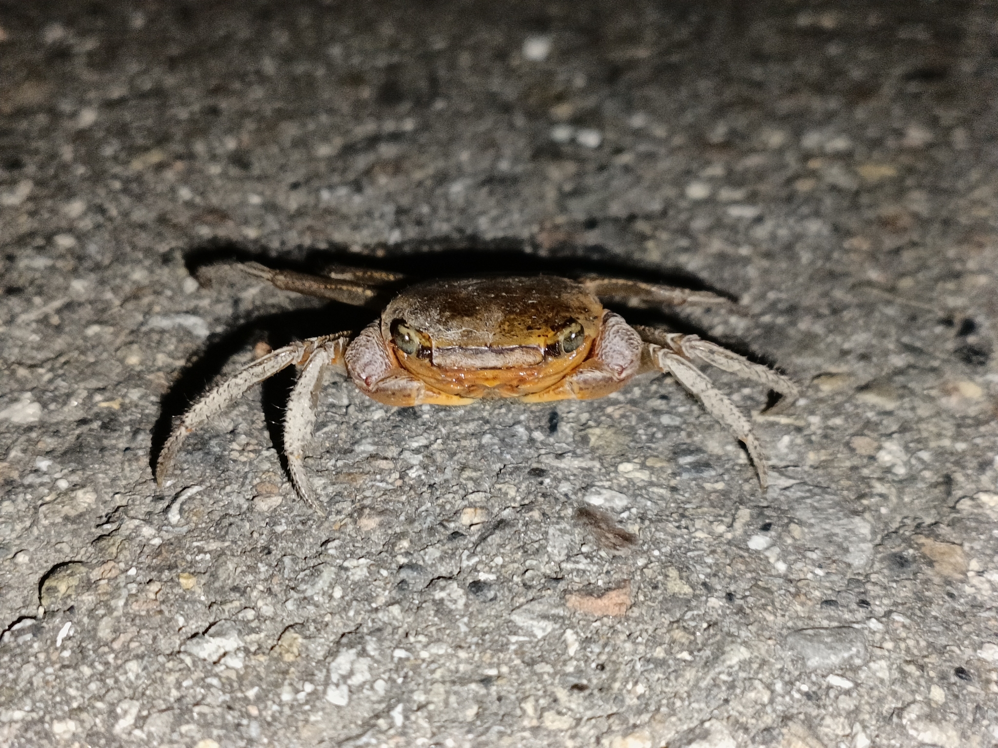
I enjoyed watching the two public television shows about Gaomei Wetlands. One of the most saddening aspects was how crabs in the area are increasingly threatened. Their habitat is being encroached upon, and mother crabs face a high mortality rate when crossing a busy road to reach the shore and release their larvae. Can you describe the situation of crabs at Gaomei and what conservationists are doing to help them?
HCL
Those are the land crabs that live around the edges of the wetlands, sheltered in the nearby protective forests and wastelands. At Gaomei Wetlands, most crabs are either the Chinese fiddler crab, the red-clawed mantis crab, or the aggressive round-spined crab. With the growing number of visitors to the area, crab roadkill has become a serious problem. The surrounding wastelands, windbreak forests, and even cemeteries are their main habitats, so when the female crabs migrate to the wetlands to release their larvae, they have to cross flood-control roads and climb embankments, which puts them at great risk.
The Gaomei Wetlands are renowned for their stunning sunsets, attracting large numbers of visitors. Unfortunately, the time when visitors leave the wetlands often coincides with the land crabs’ larval release period, resulting in severe roadkill incidents.
The design of the embankments is another factor contributing to the rising mortality rate. The steep vertical bases of the seawalls prevent land crabs from climbing over. When the Fangziliao seawalls were constructed, beach naupaka was planted along them for landscaping purposes. Invasive long-legged ants (Anoplolepis gracilipes)—known colloquially as the yellow crazy ant—inhabit the root systems of beach naupaka, where their populations are expanding. These ants are listed as one of the world’s one hundred worst invasive species.
The ants attack land crabs using formic acid, causing blindness or mobility impairment. The affected crabs gradually die from starvation or desiccation, after which they are consumed by the ants. Thus, while crossing the flood-control roads, land crabs face not only the risk of roadkill but also predation by ants, significantly reducing their chances of reaching the sea to release their larvae.
There are two main strategies for reducing land crab roadkill: traffic control and improvements to seawall design. For traffic control, vehicles could be prohibited from entering or exiting Hu-an Road—the flood-control road adjacent to the Fangziliao seawall—between 7:00 pm and 9:00 pm, from the fifth to the eighth lunar months, and during the three days following the first and fifteenth days of each lunar month. Vehicles leaving the wetlands should be directed to exit via Gaomei Road near Gaomei Kindergarten.
Regarding seawall design improvements, in areas where land crabs are highly active, seawalls could be modified to have lower bases, openings on three sides, and no vegetation—a simple, crab-friendly design. Shrubs and beach naupaka growing on the Fangziliao seawall could also be removed. Liquid bait could be used to control invasive long-legged ants and reduce their threat.

RH
The Gaomei Wetlands have become a premier tourist destination. When I visited, I found the area teeming with tourists, which felt incongruous. On the one hand, the scenery was undeniably beautiful, but the swarms of people and their interactions felt more reminiscent of a theme park than an experience of nature. The tension between conservation and tourism is difficult to resolve. What impact does tourism have on the wetlands, and how might a better balance between conservation and visitor access be achieved?
HCL
The Gaomei Wildlife Conservation Area is currently divided into three management zones: the core zone, the buffer zone, and the sustainable-use zone. Visitors can walk to the far end of the boardwalk and descend to the sandy flats. As visitor numbers have risen, heavy foot traffic has significantly hardened the substrate. This tourist activity can disturb the benthic crabs, as reflected in their lower population numbers.
The Wildlife Conservation Area should be restored to its intended purpose, with visitors staying on the embankments to observe the wildlife and enjoy the scenery from a distance. If that’s not feasible, we recommend implementing a limit on the number of people allowed to visit.
Our research indicates that levels below 15.9% of current visitor totals would be considered uncrowded. With a psychologically and socially acceptable density of 2.1 m² per person (about 600 people) on the Gaomei Wetlands’ boardwalk, management measures should be implemented when capacity reaches 966 people. This aligns closely with the 1,000-person limit proposed in the Gaomei Wetlands Conservation Plan (Ministry of the Interior, 2017).
We recommend that the city government and relevant agencies develop proactive management strategies. These could include instituting caps on the number of visitors allowed on the boardwalk, charging entrance or cleaning fees, or requiring participation in guided tours led by trained staff. Effectively managing access to the sandflats would enhance both the quality of the environment and the educational experience.
This interview was commissioned by the Taichung Art Museum and first published in the fifth issue of The Subconscious Restaurant, the sister publication of White Fungus. The issue formed part of a collaborative project tied to the museum's inaugural exhibition, A Call of All Beings: See You Tomorrow, Same Time, Same Place.


